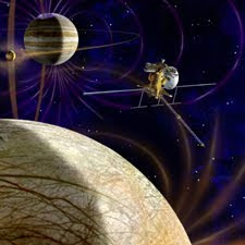
 With input from scientists around the world, American and European scientists working on the potential next new mission to the Jupiter system have articulated their joint vision for the Europa Jupiter System Mission. The mission is a proposed partnership between NASA and the European Space Agency. The scientists on the joint NASA-ESA definition team agreed that the overarching science theme for the Europa Jupiter System Mission will be "the emergence of habitable worlds around gas giants." The proposed Europa Jupiter System Mission would provide orbiters around two of Jupiter's moons: a NASA orbiter around Europa called the Jupiter Europa Orbiter, and an ESA orbiter around Ganymede called the Jupiter Ganymede Orbiter.
"We've reached hands across the Atlantic to define a mission to Jupiter's water worlds," said Bob Pappalardo, the pre-project scientist for the proposed Jupiter Europa Orbiter, who is based at NASA's Jet Propulsion Laboratory in Pasadena, Calif. "The Europa Jupiter System Mission will create a leap in scientific knowledge about the moons of Jupiter and their potential to harbor life." The new reports integrate goals that were being separately developed by NASA and ESA working groups into one unified strategy. The ESA report is being presented to the European public and science community this week, and the NASA report was published online in December.
The proposed mission singles out the icy moons Europa and Ganymede as special worlds that can lead to a broader understanding of the Jovian system and of the possibility of life in our solar system and beyond. They are natural laboratories for analyzing the nature, evolution and potential habitability of icy worlds, because they are believed to present two different kinds of sub-surface oceans. The Jupiter Europa Orbiter would characterize the relatively thin ice shell above Europa's ocean, the extent of that ocean, the materials composing its internal layers, and the way surface features such as ridges and "freckles" formed. It will also identify candidate sites for potential future landers.
With input from scientists around the world, American and European scientists working on the potential next new mission to the Jupiter system have articulated their joint vision for the Europa Jupiter System Mission. The mission is a proposed partnership between NASA and the European Space Agency. The scientists on the joint NASA-ESA definition team agreed that the overarching science theme for the Europa Jupiter System Mission will be "the emergence of habitable worlds around gas giants." The proposed Europa Jupiter System Mission would provide orbiters around two of Jupiter's moons: a NASA orbiter around Europa called the Jupiter Europa Orbiter, and an ESA orbiter around Ganymede called the Jupiter Ganymede Orbiter.
"We've reached hands across the Atlantic to define a mission to Jupiter's water worlds," said Bob Pappalardo, the pre-project scientist for the proposed Jupiter Europa Orbiter, who is based at NASA's Jet Propulsion Laboratory in Pasadena, Calif. "The Europa Jupiter System Mission will create a leap in scientific knowledge about the moons of Jupiter and their potential to harbor life." The new reports integrate goals that were being separately developed by NASA and ESA working groups into one unified strategy. The ESA report is being presented to the European public and science community this week, and the NASA report was published online in December.
The proposed mission singles out the icy moons Europa and Ganymede as special worlds that can lead to a broader understanding of the Jovian system and of the possibility of life in our solar system and beyond. They are natural laboratories for analyzing the nature, evolution and potential habitability of icy worlds, because they are believed to present two different kinds of sub-surface oceans. The Jupiter Europa Orbiter would characterize the relatively thin ice shell above Europa's ocean, the extent of that ocean, the materials composing its internal layers, and the way surface features such as ridges and "freckles" formed. It will also identify candidate sites for potential future landers.

NASA's Mars Opportunity rover is getting important tips from an orbiting spacecraft as it explores areas that might hold clues about past Martian environments. Researchers are using a mineral-mapping instrument aboard NASA's Mars Reconnaissance Orbiter (MRO) to help the rover investigate a large ancient crater called Endeavour. MRO's Compact Reconnaissance Imaging Spectrometer for Mars (CRISM) is providing maps of minerals at Endeavour's rim that are helping the team choose which area to explore first and where to go from there. As MRO orbits more than 150 miles high, the CRISM instrument provides mapping information for mineral exposures on the surface as small as a tennis court.
"This is the first time mineral detections from orbit are being used in tactical decisions about where to drive on Mars," said Ray Arvidson of Washington University in St. Louis. Arvidson is the deputy principal investigator for the Spirit and Opportunity rovers and a co-investigator for CRISM. Opportunity's science team chose to begin driving the rover toward the 14-mile-wide crater in 2008, after four years studying other sites in what initially was planned as a three-month mission. The rover has traveled approximately nine miles since setting out for Endeavour crater. It will take several months to reach it.
The team plans for Opportunity's exploration of Endeavour to begin at a rim fragment called Cape York. That feature is too low to be visible by the rover, but appears from orbit to be nearly surrounded by water-bearing minerals. The planned route then turns southward toward a higher rim fragment called Cape Tribulation, where CRISM has detected a class of clay minerals not investigated yet by a ground mission. Spacecraft orbiting Mars found these minerals to be widespread on the planet. The presence of clay minerals at Endeavour suggests an earlier and milder wet environment than the very acidic wet one indicated by previous evidence found by Opportunity.

Light-colored mounds of a mineral deposited on a volcanic cone more than three billion years ago may preserve evidence of one of the most recent habitable microenvironments on Mars. Observations by NASA's Mars Reconnaissance Orbiter enabled researchers to identify the mineral as hydrated silica and to see its volcanic context. The mounds' composition and their location on the flanks of a volcanic cone provide the best evidence yet found on Mars for an intact deposit from a hydrothermal environment a steam fumarole, or hot spring. Such environments may have provided habitats for some of Earth's earliest life forms. "The heat and water required to create this deposit probably made this a habitable zone," said J.R. Skok of Brown University, Providence, R.I., lead author of a paper about these findings published online today by Nature Geoscience.
"If life did exist there, this would be a promising type of deposit to entomb evidence of it a microbial mortuary." No studies have yet determined whether Mars has ever supported life. The new results add to accumulating evidence that, at some times and in some places, Mars has had favorable environments for microbial life. This specific place would have been habitable when most of Mars was already dry and cold. Concentrations of hydrated silica have been identified on Mars previously, including a nearly pure patch found by NASA's Mars Exploration Rover Spirit in 2007. However, none of those earlier findings were in such an intact setting as this one, and the setting adds evidence about the origin. Skok said, "You have spectacular context for this deposit. It's right on the flank of a volcano. The setting remains essentially the same as it was when the silica was deposited."
The small cone rises about 100 meters (100 yards) from the floor of a shallow bowl named Nili Patera. The patera, which is the floor of a volcanic caldera, spans about 50 kilometers (30 miles) in the Syrtis Major volcanic region of equatorial Mars. Before the cone formed, free-flowing lava blanketed nearby plains. The collapse of an underground magma chamber from which lava had emanated created the bowl. Subsequent lava flows, still with a runny texture, coated the floor of Nili Patera. The cone grew from even later flows, apparently after evolution of the underground magma had thickened its texture so that the erupted lava would mound up.
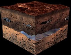
The ground where NASA's Mars Exploration Rover Spirit became stuck last year holds evidence that water, perhaps as snow melt, trickled into the subsurface fairly recently and on a continuing basis. Stratified soil layers with different compositions close to the surface led the rover science team to propose that thin films of water may have entered the ground from frost or snow. The seepage could have happened during cyclical climate changes during periods when Mars tilted farther on its axis. The water may have moved down into the sand, carrying soluble minerals deeper than less-soluble ones. Spin-axis tilt varies over timescales of hundreds of thousands of years. The relatively insoluble minerals near the surface include what is thought to be hematite, silica and gypsum.
Ferric sulfates, which are more soluble, appear to have been dissolved and carried down by water. None of these minerals is exposed at the surface, which is covered by wind-blown sand and dust. "The lack of exposures at the surface indicates the preferential dissolution of ferric sulfates must be a relatively recent and ongoing process since wind has been systematically stripping soil and altering landscapes in the region Spirit has been examining," said Ray Arvidson of Washington University in St. Louis, deputy principal investigator for the twin rovers Spirit and Opportunity. Analysis of these findings appears in a report in the Journal of Geophysical Research published by Arvidson and 36 co-authors about Spirit's operations from late 2007 until just before the rover stopped communicating in March.
The twin Mars rovers finished their three-month prime missions in April 2004, then kept exploring in bonus missions. One of Spirit's six wheels quit working in 2006. In April 2009, Spirit's left wheels broke through a crust at a site called "Troy" and churned into soft sand. A second wheel stopped working seven months later. Spirit could not obtain a position slanting its solar panels toward the sun for the winter, as it had for previous winters. Engineers anticipated it would enter a low-power, silent hibernation mode, and the rover stopped communicating March 22. Spring begins next month at Spirit's site, and NASA is using the Deep Space Network and the Mars Odyssey orbiter to listen if the rover reawakens. Researchers took advantage of Spirit's months at Troy last year to examine in great detail soil layers the wheels had exposed, and also neighboring surfaces.
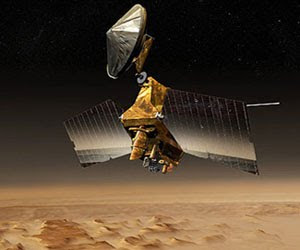
NASA's Mars Reconnaissance Orbiter put itself into a precautionary standby mode after experiencing a spontaneous computer reboot on Sept. 15. The mission's ground team has begun restoring the spacecraft to full operations. Initial analysis of telemetry from the orbiter indicates the "safe mode" status was triggered by a reboot similar to one experienced Aug. 26, 2009. That was the most recent time that the Mars Reconnaissance Orbiter put itself into safe mode. For 10 months prior to this latest reboot, the spacecraft operated normally, making science observations and returning data. During 2009, unplanned reboots put the spacecraft into safe mode four times.
The orbiter has normal power, fully charged batteries and safe temperatures. The team has increased the data-rate of communications and is taking additional steps to resume science observations soon. The Mars Reconnaissance Orbiter, at Mars since 2006, has met the mission's science goals and returned more data than all other Mars missions combined. It completed its primary science phase of operations in November 2008, but continues to observe Mars both for science and for support of future landed missions. The Mars Reconnaissance Orbiter mission is managed by NASA's Jet Propulsion Laboratory in Pasadena, Calif. Caltech manages JPL for NASA.

NASA's Lunar Reconnaissance Orbiter, or LRO, will complete the exploration phase of its mission on Sept. 16, after a number of successes that transformed our understanding of Earth's nearest neighbor. LRO completed a one-year exploration mission in a polar orbit approximately 31 miles above the moon's surface. It produced a comprehensive map of the lunar surface in unprecedented detail; searched for resources and safe landing sites for potential future missions to the moon; and measured lunar temperatures and radiation levels. The mission is turning its attention from exploration objectives to scientific research, as program management moves from NASA's Exploration Systems Mission Directorate to the Science Mission Directorate at the agency's Headquarters in Washington.
"LRO has been an outstanding success. The spacecraft has performed brilliantly," said Doug Cooke, associate administrator of the Exploration Systems Mission Directorate. "LRO's science and engineering teams achieved all of the mission's objectives, and the incredible data LRO gathered will provide discoveries about the moon for years to come." The LRO team will continue to send data gathered during the last year to the Planetary Data System, which archives and distributes scientific information from NASA planetary missions, astronomical observations and laboratory measurements. By the time LRO achieves full mission success in March, and its data is processed and released to the scientific community, it will have sent more information to the Planetary Data System than all other previous planetary missions combined. During its new phase of discovery, LRO will continue to map the moon for two to four more years.
"The official start of LRO's science phase should write a new and intriguing chapter in lunar research," said Ed Weiler, associate administrator for the Science Mission Directorate. "This mission is one more asset added to NASA's vast science portfolio." The spacecraft launched from NASA's Kennedy Space Center in Florida carrying a suite of seven instruments on June 18, 2009. LRO formally began its detailed survey of the moon in September 2009. Results from the mission include: new observations of the Apollo landing sites; indications that permanently shadowed and nearby regions may harbor water and hydrogen; observations that large areas in the permanently shadowed regions are colder than Pluto; detailed information about lunar terrain; and the first evidence of a globally distributed population of thrust faults that indicates the moon has recently contracted and may still be shrinking.
 NASA and U2 released a commemorative video highlighting a year's worth of collaboration in space and on the Irish rock band's 360 Degree tour. U2 approached NASA in 2009 with an idea to include a dialogue between the band and the crew of the International Space Station during U2's world tour. The astronauts of Expedition 20, the crew then living aboard the space station, agreed to participate and spoke with U2 several times before recording a video segment the band incorporated into its concerts. The space station crew members were Michael Barratt of NASA, Frank De Winne of the European Space Agency, Bob Thirsk of the Canadian Space Agency, Koichi Wakata of the Japan Aerospace Exploration Agency, and Gennady Padalka and Roman Romanenko of the Russian Federal Space Agency.
"Working with U2 is atypical for NASA," said Bill Gerstenmaier, NASA's associate administrator for Space Operations. "By combining their world tour with the space station's out-of-this-world mission, more people and different people than our normal target audiences learned about the International Space Station and the important work we are doing in orbit." Speaking onstage in Houston last year, Bono said, "These are the very best people in the world dedicated to figuring how our little planet exists in this cosmos we call home." De Winne, and Romanenko attended U2's performance in Moscow on Wednesday and met with the band before the show.U2.com created the video and presented it to NASA to document the collaboration between the band and the space agency.
NASA and U2 released a commemorative video highlighting a year's worth of collaboration in space and on the Irish rock band's 360 Degree tour. U2 approached NASA in 2009 with an idea to include a dialogue between the band and the crew of the International Space Station during U2's world tour. The astronauts of Expedition 20, the crew then living aboard the space station, agreed to participate and spoke with U2 several times before recording a video segment the band incorporated into its concerts. The space station crew members were Michael Barratt of NASA, Frank De Winne of the European Space Agency, Bob Thirsk of the Canadian Space Agency, Koichi Wakata of the Japan Aerospace Exploration Agency, and Gennady Padalka and Roman Romanenko of the Russian Federal Space Agency.
"Working with U2 is atypical for NASA," said Bill Gerstenmaier, NASA's associate administrator for Space Operations. "By combining their world tour with the space station's out-of-this-world mission, more people and different people than our normal target audiences learned about the International Space Station and the important work we are doing in orbit." Speaking onstage in Houston last year, Bono said, "These are the very best people in the world dedicated to figuring how our little planet exists in this cosmos we call home." De Winne, and Romanenko attended U2's performance in Moscow on Wednesday and met with the band before the show.U2.com created the video and presented it to NASA to document the collaboration between the band and the space agency.
View this site : Property auctions
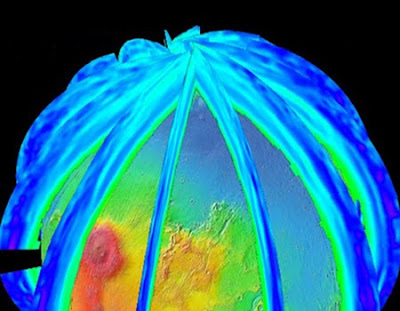
One of the instruments on a 2016 mission to orbit Mars will provide daily maps of global, pole-to-pole, vertical distributions of the temperature, dust, water vapor and ice clouds in the Martian atmosphere. The joint European-American mission, ExoMars Trace Gas Orbiter, will seek faint gaseous clues about possible life on Mars. This instrument, called the ExoMars Climate Sounder, will supply crucial context with its daily profiling of the atmosphere's changing structure. The European Space Agency and NASA have selected five instruments for ExoMars Trace Gas Orbiter. The European Space Agency will provide one instrument and the spacecraft. NASA will provide four instruments, including ExoMars Climate Sounder, which is coming from NASA's Jet Propulsion Laboratory, Pasadena, Calif.
Two of the other selected instruments are spectrometers one each from Europe and the United States designed to detect very low concentrations of methane and other important trace gases in the Martian atmosphere. "To put the trace-gas measurements into context, you need to know the background structure and circulation of the atmosphere," said JPL's Tim Schofield, principal investigator for the ExoMars Climate Sounder. "We will provide the information needed to understand the distribution of trace gases identified by the spectrometers. We'll do this by characterizing the role of atmospheric circulation and aerosols, such as dust and ice, in trace-gas transport and in chemical reactions in the atmosphere affecting trace gases."
The ExoMars Climate Sounder is an infrared radiometer designed to operate continuously, day and night, from the spacecraft's orbit about 400 kilometers (about 250 miles) above the Martian surface. It can pivot to point downward or toward the horizon, measuring temperature, water vapor, dust and ices for each 5-kilometer (3-mile) increment in height throughout the atmosphere from ground level to 90 kilometers (56 miles) altitude. Schofield and his international team have two other main goals for the investigation, besides aiding in interpretation of trace-gas detections. One is to extend the climate mapping record currently coming from a similar instrument, the Mars Climate Sounder, on NASA's Mars Reconnaissance Orbiter, which has been working at Mars since 2006.
View this site : Property auctions
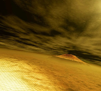
In fact, it might be much like Mars, says JPL planetary scientist David Kass. The Red Planet today has relatively few clouds compared to Earth. That's because the Martian atmosphere contains less than a tenth of a percent of the amount of water vapor found in Earth's atmosphere. Without much water vapor, and with temperatures averaging 80 degrees Celsius (176 degrees Fahrenheit) colder than on Earth, only thin ice clouds form. They tend to look like a thinner version of Earth's wispy cirrus clouds. "We don't think that clouds on Mars get to the point where you couldn't see the sun through them, but they might get thick enough that you could look at the sun through them without hurting your eyes," sats Kass.
Mars also has thicker clouds made of frozen carbon dioxide commonly called dry ice that form both high in the atmosphere and at the poles during winter, where the sun never rises for half the Mars year. These clouds are dense enough to dim the sun's light by about 40 percent, but because they are found only in limited regions near the planet's poles and equator, they are unlikely to affect the Martian climate as a whole. Scientists theorize that the relatively sparse clouds on Mars allow temperatures to rise and fall dramatically. Without the cooling effect of significant cloud shade or the insulating effect of thick cloud blankets, the surface of Mars heats drastically during the day reaching temperatures around 18 degrees Celsius at the equator before the temperature plummets at night to equatorial surface temperatures as cold as 130 degrees Celsius below freezing.
But researchers don't yet know for certain how exactly Martian clouds affect the planet's climate. "It's not clear yet how big a role clouds play in Mars' climate," says Kass. "This is really on the cutting edge right now." As planetary climate models become more sophisticated, they will include the radiative effects of the clouds seen in data from the Mars Climate Sounder on NASA's Mars Reconnaissance Orbiter. Kass says the modelers will be able to incorporate that data and examine cases with and without clouds to see their impacts. "We hope to know more soon," Kass adds.

Mars rover team members have begun informally naming features around the rim of Endeavour Crater, as they develop plans to investigate that destination when NASA's Opportunity rover arrives there after many more months of driving. A new, super-resolution view of a portion of Endeavour's rim reveals details that were not discernible in earlier images from the rover. Several high points along the rim can be correlated with points discernible from orbit.
Super-resolution is an imaging technique combining information from multiple pictures of the same target to generate an image with a higher resolution than any of the individual images. Endeavour has been the team's long-term destination for Opportunity since the summer of 2008, when the rover finished two years of studying Victoria Crater. By the spring of 2010, Opportunity had covered more than a third of the charted, 19-kilometer (12-mile) route from Victoria to Endeavour and reached an area with a gradual, southward slope offering a view of Endeavour's elevated rim.
After the rover team chose Endeavour as a long-term destination, the goal became even more alluring when observations with the Compact Reconnaissance Imaging Spectrometer for Mars, on NASA's Mars Reconnaissance Orbiter, found clay minerals exposed at Endeavour. Clay minerals, which form under wet conditions, have been found extensively on Mars from orbit, but have not been examined on the surface. Additional observations with that spectrometer are helping the rover team choose which part of Endeavour's rim to visit first with Opportunity.
 With input from scientists around the world, American and European scientists working on the potential next new mission to the Jupiter system have articulated their joint vision for the Europa Jupiter System Mission. The mission is a proposed partnership between NASA and the European Space Agency. The scientists on the joint NASA-ESA definition team agreed that the overarching science theme for the Europa Jupiter System Mission will be "the emergence of habitable worlds around gas giants." The proposed Europa Jupiter System Mission would provide orbiters around two of Jupiter's moons: a NASA orbiter around Europa called the Jupiter Europa Orbiter, and an ESA orbiter around Ganymede called the Jupiter Ganymede Orbiter.


