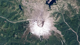
Mt. St. Helens exploded 32 years ago on May 18. It began with a small series of earthquakes and culminated with the volcano erupting, a cataclysmic collapse of the flank of the mountain and the largest landslide in recorded history.
This time series of data shows the explosion and subsequent recovery of life on the volcano. Landsat, a satellite program operated by NASA and the U.S. Geological Survey acquired the images between 1979 and 2011. In them, scientists have an unprecedented opportunity to witness how life recovers from devastation.The animation begins with vegetation as red because early Landsat satellites couldn't 'see' blue light. That changed with launch of Landsat 5 in 1984 and its natural color abilities.
The collapse of the mountain was like uncorking a bottle of champagne. Fifty-seven people died when rocks, hot ash, gas and steam exploded out of the Earth. The blast debris, which is gray in the images, covered over 230 square miles (600 square kilometers) and blew down 4 billion board-feet of timber.

No comments:
Post a Comment