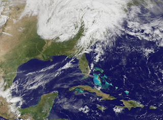
A powerful weather system moved through eastern Texas and dropped at least 15 tornadoes in the Dallas suburbs. NASA created an animation of data from NOAA's GOES-13 satellite that shows the frontal system moving through the region yesterday.
NOAA's Geostationary Operational Environmental Satellite, GOES-13, captures visible and infrared images of weather over the eastern U.S. every 15 minutes, and captured the movement of the weather system that generated the Texas twisters. The 23 second movie runs from April 2 at 1615 UTC through April 4 at 1615 UTC (11:15 a.m. CDT), and shows the progression of the storm system that generated about 15 tornadoes on April 3. Around 2215 UTC (5:15 p.m. CDT) on April 3, the tail end of the front appeared in the GOES animation as a pie-shaped wedge that continued to thin out. It is that wedge where the tornadoes were generated and touched down in the southeastern Dallas suburbs. One thing people viewing the video can take from the satellite view is that if they're seeing GOES imagery live on television, they can relate wedge shaped-frontal clouds with severe weather and be prepared.
NOAA operates the GOES series of satellites, and NASA's GOES Project, located at NASA's Goddard Space Flight Center in Greenbelt, Md. compiles the images into animations. The GOES visible and infrared data is compiled and then overlayed on a true-color land surface map of the U.S. that was created using data from the Moderate Resolution Imaging Spectroradiometer instrument that flies on NASA's Aqua and Terra satellites.
For more information about: Low cost business airline companies
For more information about: Low cost business airline companies

No comments:
Post a Comment